About
Gallery
Research
Wind Setup in the Indian River Lagoon
Determining Wave Properties with Video
Surface Roughness in Coastal Estuaries
Tropical
Tropical Weather Outlook
Atlantic Satellite Imagery
More Tropical Info
Space Coast
KMLB Forecast & Discussion
SPC Activity & Latest Sounding
Ionospheric Propagation
Surf Forecasts
Fire Weather
Radar
Base Reflectivity
Base Velocity
Storm Relative Velocity
Correlation Coefficient
Home
Orion Weather
Florida Space Coast and Tropical Weather
Forecasts from Melbourne National Weather Service (MLB)
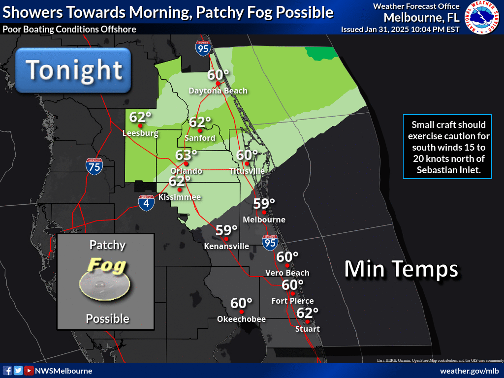
Impact Weather Graphic:
Area Forecast Discussion from MLB:
FXUS62 KMLB 281427 AFDMLB Area Forecast Discussion National Weather Service Melbourne FL 1027 AM EDT Sun Apr 28 2024 ...New UPDATE, AVIATION, MARINE... .UPDATE... (Through Today) Issued at 1026 AM EDT Sun Apr 28 2024 Key Messages: -High risk of rip currents at Atlantic beaches. -Poor to hazardous boating conditions continue today. -Warming up, mostly dry through the new work week. Forecast is in good shape this morning. The latest sounding off the Cape (28/10Z XMR) revealed a tiny area of CAPE trapped below an inversion near and above H85. This positive area is much more shallow than yesterday; consequently, shower chances are lower at 10-20% this afternoon. More likely than not, a few sprinkles or trace amounts would be the most we can squeeze out. With only a few light radar returns approaching the Volusia coast right now, this checks out. Otherwise, partly sunny skies prevail. Highs should respond into the low/mid 80s over the interior with upper 70s/low 80s along the coast. It will remain breezy with a few easterly gusts 20-25 mph. Beach-goers will still experience rough surf and a high risk of rip currents; it is best to stay out of the water today! && .AVIATION... (12Z TAFs) Issued at 1026 AM EDT Sun Apr 28 2024 Still have VCSH in for a few terminals this afternoon as ~ 20% shower chances persist. Otherwise, VFR should prevail with steady east winds 10-20 KT, strongest at the coast with occasional 25KT gusts through early evening. No significant aviation impacts expected. && .MARINE... Issued at 1026 AM EDT Sun Apr 28 2024 Through Tonight...Seas are slow to subside offshore this morning, remaining around 7 FT 20 nm E of Port Canaveral. Though winds have lessened a bit, we did decide to extend the Small Craft Advisory for offshore waters until 4 PM ET. Otherwise, nearshore operators should exercise caution for 4-6 FT seas through the afternoon. Tonight, ESE winds hold around 10-15 KT with general seas 3-5 FT, locally 6 FT well offshore. At least a moderate wind chop on inland waterways today. Monday-Wednesday...(previous disc.) A relaxing pressure gradient as the surface high pressure drifts seaward will allow for improving boating conditions through mid week. Seas of 4-5 ft on Monday will subside to 3-4 ft late Tuesday as east to southeast winds up to 15 knots drop to 10-15 knots through mid week. Isolated showers over the Atlantic waters will be possible each day, but lightning is not forecast. && .FIRE WEATHER... Issued at 243 AM EDT Sun Apr 28 2024 Today...The pressure gradient remains tight across ECFL, again. ERLY wind speeds 15-20 mph with gusts to 25-30 mph, especially later this morning and afternoon. Winds do diminish this evening, gradually, 5-10 mph interior and 10-15 mph coast (with higher gusts here). Min aftn RH's 40-45pct well into interior and 45- 55pct towards the coast. Dispersions remain VG-EX! Few sprinkles, brief light showers around again this morning, early afternoon, but any already very ISOLD trend should be diminishing further into the afternoon as drier air moves into the area. This Week...While breezy conditions early in the week begin to subside, fire sensitive conditions will continue as a warming trend commences. Minimum RH values will drop below 40% across the interior each afternoon, most prominently across Lake and western Osceola counties. Light passing showers will be possible on Monday, but otherwise rain remains out of the forecast this week. && .PREVIOUS DISCUSSION... (Monday-Saturday) Issued at 243 AM EDT Sun Apr 28 2024 This Week...A stagnant pattern will remain in place over the next 7 days, with very little day to day change. An upper level ridge remains anchored over the eastern CONUS, with the surface high pressure offshore from the Carolinas drifting only slightly seaward by mid week. The pressure gradient will begin to relax on Monday, but still, deep east to southeasterly flow will hold steady towards next weekend. Will continue to carry a slight chance for showers over the Atlantic waters each day as trapped moisture wraps around the periphery of the high. On Monday, mentionable rain chances will be present along the entire east central FL coastline, retreating just to the Treasure Coast on Tuesday. No thunder is forecast, and any showers should be very brief and quick moving. Temperatures will climb a few degrees each day, with the low 80s at the coast and mid/upper 80s inland on Monday approaching 90 degrees by Wed/Thu (still cooler at the coast with the oceanic influence). Lows persist at seasonable values in the mid 60s. && .PRELIMINARY POINT TEMPS/POPS... DAB 79 64 81 65 / 20 0 10 0 MCO 81 63 86 65 / 10 0 10 0 MLB 79 66 81 67 / 20 0 20 10 VRB 81 64 83 65 / 20 0 20 10 LEE 83 63 86 65 / 10 0 0 0 SFB 81 63 85 65 / 10 0 10 0 ORL 82 64 86 66 / 10 0 10 0 FPR 80 64 83 65 / 20 0 20 10 && .MLB WATCHES/WARNINGS/ADVISORIES... FL...None. AM...Small Craft Advisory until 11 AM EDT this morning for AMZ555. Small Craft Advisory until 4 PM EDT this afternoon for AMZ570- 572-575. && $$ UPDATE...Heil LONG TERM...Schaper AVIATION...Heil DECISION SUPPORT...Weitlich
MLB Daily Graphics
MLB Graphical Forecast